The Jakarta Post
Please Update your browser
Your browser is out of date, and may not be compatible with our website. A list of the most popular web browsers can be found below.
Just click on the icons to get to the download page.


Popular Reads
Top Results
No results found. Please check your search term and try again
Can't find what you're looking for?
View all search results
Popular Reads
Top Results
No results found. Please check your search term and try again
Can't find what you're looking for?
View all search resultsExpert: Indonesia needs fire risk maps, food project reevaluation amidst Merauke wildfires
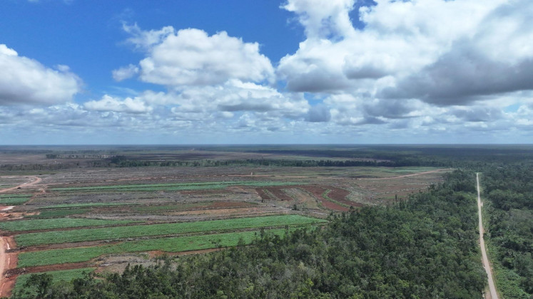
Data from MapBiomas showed that areas with the most extensive fire damage are distributed across various food production hubs and agricultural regions, with Merauke in South Papua topping the list at the regency level.
Change text size
Gift Premium Articles
to Anyone
Share the best of The Jakarta Post with friends, family, or colleagues. As a subscriber, you can gift 3 to 5 articles each month that anyone can read—no subscription needed!
 Set as preferred source
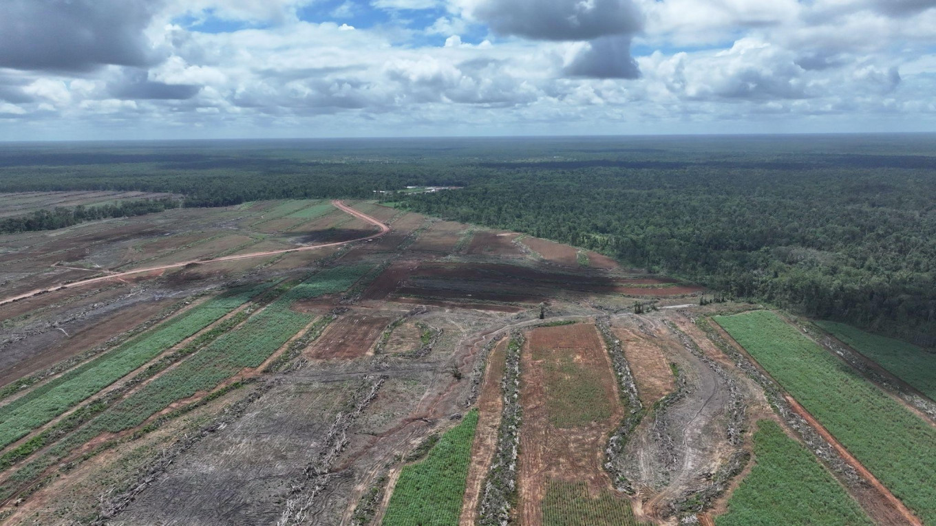 Cleared land earmarked for food estate projects is parched next to the remaining forest canopy in Merauke, South Papua. (Images courtesy of Auriga Nusantara)
E
xperts have called for Indonesia to develop fire risk maps for its food estates as the archipelago grapples with wildfires and haze, exacerbated by unprecedented El Nino conditions.
The MapBiomas Monthly Fire 2026 report, published by the nonprofit Auriga Nusantara, showed that between January and June 2026, Indonesia lost 178,232 hectares of land to fires, roughly three times the size of Singapore and 66 percent larger than the government's initial estimates.
30 percent of the fires occurred in agricultural areas, with 22,703 ha of the burned land located within food project zones. In particular, a total of 8,084 ha of food project land burned in Merauke, South Papua, accounting for approximately 36 percent of all burned areas within national food projects.

Ibrahim Fahmi Badoh, director of communications and advocacy at Auriga Nusantara, highlighted the need for fire risk maps as a fundamental prerequisite for any food projects, adding that areas with a history of frequent fires require special handling and should, if necessary, be excluded from project expansion.
“With such a significant figure, Merauke serves as a warning regarding how we design food security projects,” Ibrahim said.
“If food projects are established in fire-prone landscapes without robust prevention systems, the government creates a paradox, where the state allocates funds to develop rice paddies, build irrigation, open access routes and provide production inputs, yet simultaneously allows fire to destroy the ecological foundation upon which these efforts rest,” he said.
“Prevention, rather than mere suppression, must be the priority.”
Widespread overlaps
MapBiomas Fire, an initiative by MapBiomas Indonesia developed by a network of civil society organizations across the country, recorded that the most extensive fires were spread across various food hubs and agricultural regions.
Kalimantan accounted for 37,665 ha of burned land, followed by Bali and Nusa Tenggara (33,338 ha), Papua (25,946 ha), Sumatra (25,198 ha), Sulawesi (23,300 ha), Java (20,855 ha) and Maluku (11,929 ha). In June alone, the burned area increased by 173 percent compared to the previous month.
At the regency level, Merauke topped the list with 14,108 ha of burned land, followed by Central Sumba, East Sumba, Ketapang, Kubu Raya, Mempawah, Bima, Bombana, Bengkalis and Bojonegoro.
According to Ibrahim, the list is noteworthy as it demonstrates that fires are not a problem exclusive to remote forest areas as they occur in key centers for agriculture and food production.

MapBiomas’ data, which utilizes computational technology powered by machine learning and deep learning algorithms applied to satellite imagery, aligns with a spatial analysis conducted by the WALHI National Executive in collaboration with WALHI Papua.
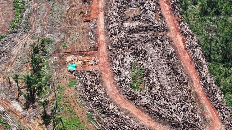
An overlay of hotspot data from July 1 to 9 with maps of concessions and National Strategic Program (PSN) areas reveals that at least 399 hotspots are located within areas subject to permits or allocated for national food projects. Of these, 245 hotspots are situated in food estate zones, 115 in PBPH (Forest Utilization Business Permit) concessions, and 39 in oil palm plantation concessions.
The findings indicate that nearly one-third of the 1,292 hotspots in South Papua appeared in areas where land-use interventions had already occurred through the issuance of business permits or the development of national strategic projects.
“Consequently, it is evident that the hotspots in South Papua did not occur randomly; their distribution reveals a distinct pattern concentrated within landscapes allocated by the government or corporations for large-scale food projects and various types of concessions,” Ibrahim explained.
To that end, he continues, early warning systems must link local governments, farmer groups, indigenous communities, concession holders and law enforcement agencies. In addition, satellite-based monitoring such as MapBiomas must serve as the basis for action before fires escalate.
Beyond self-sufficiency
While fire prevention and suppression efforts are essential, Ibrahim implored the government to redefine how the success of food estates is measured.
Success, he explains, cannot be gauged solely by the number of ha of paddy fields opened or tons of rice harvested, as it must also take into account other indicators such as soil quality, water availability and production sustainability, as well as loss of natural cover and potential land conflicts.
Ibrahim opined that true food security entails ensuring long-term land productivity, water availability and ecosystem functionality, while providing farmers with certainty and keeping disaster risks under control.
“The fires in Merauke and other food production hubs must mark a turning point. The government needs to demonstrate that a food estate is not merely a project to open up new production areas, but a food system resilient to climate change and fire. Otherwise, we are making a costly mistake: burning away the present in pursuit of tomorrow's food.
“If fire remains a recurring theme in the story of food estate development, the food estate will have failed to safeguard the very land meant to serve as our source of sustenance,” he concluded.
More from The Weekender

Radio still gives you something an algorithm can't
You can choose almost anything you want to hear these days. So why are young people still tuning in to radio?

Travels in the land of Gen Z (Part 2)
Beyond the fragility and short attention span, my students proved sharper, more open-minded and more generous than I’d expected. Second of two parts. Read the first here.

Is AI really making us better workers?
AI can make our work faster and more polished. But by eliminating the struggle, mistakes and imperfections, it may also be eliminating some of the ways we learn and become better workers.